Media Contact
Email: media@floodpanel.com

Records were broken last month as massive amounts of rain swamped parts of Long Island. During the 24-hour period beginning on the morning of Wednesday, August 13, 2014, more rain fell than during any similar period in recorded history. At the weather station on Long Island, more than 13″ of rain was recorded.
Unfortunately, this rainfall occurred before and during morning rush hour traffic, and caused widespread havoc and panic as cars actually floated on the roads. One driver was killed during the chaos, and numerous traffic accidents added to the logjam.
Vehicles attempt to maneuver down a flooded Montauk Highway in Babylon, N.Y., Wednesday August 13, 2014. The National Weather Service reported that parts of Long Island experienced record-setting rainfall in a 24 hour period. In one community, more than 13 inches of rain was reported. (AP Photo/Frank Eltman)
The storm resulted in large-scale damage across a wide swath of the island, affecting homeowners and businesses alike. Streams and rivers flooded universally, and any properties near these waterways were likely to have flooding and damage.
Sinkholes were also a problem, and in one town a car narrowly avoided being swallowed up by a sudden chasm in the road. More than 50 people had to be rescued by emergency personnel when their cars became stranded or stalled by floodwaters. One motorist, whose car was mired in almost six feet of swirling water, had to be saved when his car began to fill with water.
With hundreds of cars abandoned on streets and highways, navigation was extremely difficult and dangerous. At times, the abandoned cars would be picked up and carried by the current, creating a threat to emergency vehicles trying to move through the water on rescue missions. Boats were required to rescue people who were stranded in the middle of “lakes” that had formed where parking lots had stood just hours or even minutes before.
Flash flooding was a problem throughout much of Long Island, and quickly turned highways into rivers. Although the storm largely avoided populous New York City, other parts of New York were affected, as well as parts of New Jersey and Connecticut. Damage to homes and businesses was severe in some areas. A few very unlucky people who had experienced total loss of their homes during Hurricane Sandy suffered major damage to their new homes in this storm.
Many outlying suburbs were very hard-hit by flash flooding, resulting in widespread property damage. Unless flood barriers were in place, any low-lying area became an instant lake, up to several feet deep in some places. Trucks with snowplows attached could be seen pushing water out of apartment parking lots in an effort to minimize flooding at the property.
The storm was so severe that parts of Long Island and surrounding environs were forced to declare a state of emergency, freeing up funds to pay for rescue personnel and equipment. Once again, Long Island and other low-lying communities felt the full fury of nature, as storm-driven flooding swept through these districts. And once again, thoughts now turn to flood barriers and other methods of prevention … for the next storm.
Source:: FloodBarrierUSA 2
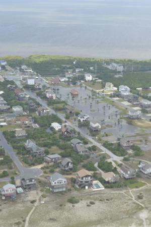
Hatteras Island Flooding (Courtesy U.S. Coast Guard)
The first hurricane of the 2014 season, Hurricane Arthur, was initially feared and dreaded as it barreled up the same path taken by the infamous Hurricane Sandy a year ago. It made landfall near the State of North Carolina, and left tens of thousands of people without power. The popular resort island of Cape Hatteras was under mandatory evacuation, spoiling the vacations of thousands of visitors, and impacting tourism-related businesses on the busiest holiday of the summer season.
In the end, the hurricane moved through quickly, and did not dump the expected amount of rain, before veering northeast- back over the Atlantic Ocean. This was the best possible scenario for this event, and the heavily populated northeastern US coast was spared an ugly repeat of last year’s disaster. The storm then weakened to a Category I, and did not greatly impact other states as it moved offshore towards Canada.
North Carolina, however, did not escape unscathed. More than 44,000 homes were left without power, and there was widespread flooding. The flooding impacted not only coastal residents, but those living near streams and rivers, as the storm surge pushed massive amounts of water into the riparian zones far from the ocean.
One resident, according to a news report, could barely see the tip of the six-foot tall lamppost at the end of his driveway — the rest was underwater. In these low-lying areas, even a “mild” hurricane can inflict unimaginable property damage and millions of dollars in damage and lost income. The holiday weekend was particularly important from an economic standpoint, as frequent hurricanes during the past three years have been hammering the tourism industry.
The area most impacted by Hurricane Arthur was the Outer Banks region, including Hatteras, which was under mandatory evacuation orders. Some parts of these islands received over 8 inches of rain in a brief period of time; leading to floods, beach erosion, and downed power lines. Instead of enjoying fireworks on the Fourth of July, residents and business owners were desperately cleaning up in an effort to salvage some of the all-important holiday business.
In addition to the hurricane and the accompanying floods, several tornados were spawned by the storm. These eventually disappeared, and for the most part, the storm passed by the US eastern seaboard with relatively little damage — particularly compared to other recent storms. The good news is that people seem to have learned from Hurricane Sandy, and they took the storm seriously and got out of the way. Still, a few reckless surfers were seen heading to the beach with boards in tow.
Source: http://www.floodbarrierusa.com/

Throughout human history, flooding has been both a gift and a curse. The ancient civilizations that grew up in Egypt and Mesopotamia would not have developed the way they did without flooding. Both of these areas suffered — and benefited — from regular flooding.
Egypt was lucky enough to have flooding that was gradual, regular, and predictable. The Nile River, after swelling with rain runoff from central Africa, would flood the surrounding countryside and then recede, leaving black loamy soil that was bursting with fertility. Because of the rich fertility of the flood lands, it was possible to build up a surplus of food, enabling the people to turn their attention to other endeavors, such as art, music, and religion. The Nile was therefore seen as a beneficent force in the lives of ancient Egyptians.
First Suez Canal dug by the pharaoh Sesostris I in 1960 BC. Inspired by a map from the book “Suez & Panama” by Benedict Heimermann, Arthaud edition. Author: Annie Brocolie
Sumerians, on the other hand, came to view their rivers as a dreadful scourge. Nestled between the Tigris and Euphrates rivers, the land formerly called Mesopotamia (modern-day Iraq) was a huge floodplain that endured frequent and often devastating floods, dominating all aspects of life. It is here that two of the most famous flood myths —the stories of Noah and Gilgamesh — originated. Although science tells us that these floods were not global, they must have seemed that way to those suffering through them.
Both the Egyptians and the Sumerians learned to use their rivers for irrigation and for soil replenishment. The Egyptians, blessed with predictable and relatively benign flood patterns, learned to coexist with the flooding — moving to higher ground in advance of the flood season. The Sumerians were forced to develop strategies for taming and controlling their unpredictable rivers; and it was here that the first artificial flood barriers evolved.
A river that floods regularly will produce natural levees in the form of elevated banks. Heavy soil and material builds up along the edges of the river, leaving the lighter silts to spread across the floodplain during an inundation. The Sumerians, living on their vast floodplain, observed that the embankments provided some protection, and began to build their homes on these natural levees. Later, they built artificial mounds out on the floodplain to elevate and protect their homes. But even this was not enough to tame the destruction of the unpredictable flooding, so gradually the Sumerian people honed their skills, becoming one of the first known groups to build dams, canals, and flood barriers.
The Sumerian flood control projects were massive, even by today’s standards. Huge flood barriers and embankments were built all along the banks of the two mighty rivers — essentially, thousands of miles of flood barriers were put into place. Canals and floodgates governed the flow of water for irrigation in times of dry weather, and helped to channel floodwaters during rainy times. These were the first known man made flood barriers in all the world.
Today we have many types of flood barriers — both natural and artificial. From natural berms and dunes to fully automatic flood panels, options now exist for almost any type of situation and environment. But all these flood-control methods owe at least some debt to the ancient Sumerian culture — the first people known to attempt to tame the floods.
Source: http://www.floodbarrierusa.com/

Many coastal US cities face astronomical flood loss bills every year. For example, the average yearly cost of flooding in New Orleans is $1,583,000,000, in New York it is $1,960,000,000, and in Miami it is a whopping $2,099,000,000. These three cities alone account for the vast majority of flood loss costs in the US each year.
Analysts for the OECD (Organisation for Economic and Co-operation Development) ranked major cities in terms of population and ‘assets’ to a 1-in-100 year flood event now and in the future.
As daunting as these sums may seem, they are dwarfed by the bills that have been projected for the future, as sea levels rise and more assets continue to be packed into these desirable areas. A recent study has concluded that flood losses in US coastal cities may well quadruple by the year 2050, unless stringent efforts are made to ameliorate the risks.
In fact, the three cities mentioned above will account for a staggering 31% of all losses GLOBALLY unless extreme measures are taken to defend them against the floods of the future. By all estimates and computer projections, the floods of the future will increase by an order of magnitude of up to 50. This means that coastal cities must now prepare to defend themselves against storms that are many times more destructive than hurricanes Sandy or Katrina.
Failure to prepare for these future super-storms will result in crippling losses that can break the global economy. Without making changes, by simply going along with the present level of flood protection, flood damages will soon be measured in the trillions of dollars, rather than millions.
Conversely, if US cities plan well and adequately prepare for the coming challenges, flood losses may be held at reasonable levels. With proper flood protection measures in place, losses could be kept as low as $50 million in the year 2050. These studies clearly tell us that flood protection, prevention, and preparation is many times cheaper than cleaning up the mess after a major storm. Upgrading flood defenses will provide a huge economic payoff, while complacency could literally destroy major economies.
Experts agree that flood preparation and prevention is crucial to the survival of coastal cities. Sea level rise, coupled with ever-increasing population and, in some cases, the tendency of some low-lying areas such as New Orleans and Miami to actually sink- presents a major threat to financial assets and human life. Defenses will need to include flood barriers, sea walls and levees, pumping and bilging, and very stringent planning for new construction.
There are many aphorisms that express this prudent approach: ‘a stitch in time saves nine’ or ‘an ounce of prevention is worth a pound of cure’. When it comes to preparing for the mammoth storms that are certain to pound the coastlines in the coming decades, these aphorisms hold a wealth of wisdom. The real challenge will be to make sure preventive measures are already in place BEFORE the storms arrive.
Source: http://www.floodbarrierusa.com/